പേജുകള്‍‌

Alexandria


Alexandria in Egyptian Arabic) is the second largest city in Egypt, with a population of 4.1 million, extending about 32 km (20 mi) along the coast of the Mediterranean Sea in the north central part of the country. It is also the largest city lying directly on the Mediterranean coast. Alexandria is Egypt's largest seaport, serving approximately 80% of Egypt's imports and exports. It is an important industrial center because of its natural gas and oil pipelines from Suez. Alexandria is also an important tourist resort.

Alexandria was founded around a small pharaonic town c. 331 BC by Alexander the Great. It remained Egypt's capital for nearly a thousand years, until the Muslim conquest of Egypt in AD 641, when a new capital was founded at Fustat (later absorbed into Cairo). Ancient Alexandria was best known for the Lighthouse of Alexandria (Pharos), one of the Seven Wonders of the Ancient World; its library (the largest in the ancient world; now replaced by a modern one); and the Catacombs of Kom el Shoqafa, one of the Seven Wonders of the Middle Ages. Ongoing maritime archaeology in the harbor of Alexandria, which began in 1994, is revealing details of Alexandria both before the arrival of Alexander, when a city named Rhacotis existed there, and during the Ptolemaic dynasty.

From the late 19th century, Alexandria became a major center of the international shipping industry and one of the most important trading centers in the world, both because it profited from the easy overland connection between the Mediterranean Sea and the Red Sea, and the lucrative trade in Egyptian cotton.


Alexandria was founded by Alexander the Great in April 331 BC as Ἀλεξάνδρεια (Alexandria). Alexander's chief architectfor the project was Dinocrates. Alexandria was intended to supersede Naucratis as a Hellenistic center in Egypt, and to be the link between Greece and the rich Nile Valley. An Egyptian city, Rhakotis, already existed on the shore, and later gave its name to Alexandria in the Egyptian language (Egyptian *Raˁ-Ḳāṭit, written rˁ-ḳṭy.t, 'That which is built up'). It continued to exist as the Egyptian quarter of the city. A few months after the foundation, Alexander left Egypt and never returned to his city. After Alexander's departure, his viceroy, Cleomenes, continued the expansion. Following a struggle with the other successors of Alexander, his general Ptolemy succeeded in bringing Alexander's body to Alexandria, though it was eventually lost after being separated from its burial site there.

Although Cleomenes was mainly in charge of overseeing Alexandria's continuous development, the Heptastadion and the mainland quarters seem to have been primarily Ptolemaic work. Inheriting the trade of ruined Tyre and becoming the center of the new commerce between Europe and the Arabian and Indian East, the city grew in less than a generation to be larger than Carthage. In a century, Alexandria had become the largest city in the world and, for some centuries more, was second only to Rome. It became Egypt's main Greek city, with Greek people from diverse backgrounds.

Alexandria was not only a center of Hellenism, but was also home to the largest urban Jewish community in the world. The Septuagint, a Greek translation of the Hebrew Bible, was produced there. The early Ptolemies kept it in order and fostered the development of its museum into the leading Hellenistic center of learning (Library of Alexandria), but were careful to maintain the distinction of its population's three largest ethnicities: Greek, Jewish, and Egyptian.[3] From this division arose much of the later turbulence, which began to manifest itself under Ptolemy Philopater who reigned from 221–204 BC. The reign of Ptolemy VIII Physcon from 144–116 BC was marked by purges and civil warfare.[citation needed]

The city passed formally under Roman jurisdiction in 80 BC, according to the will of Ptolemy Alexander, but only after it had been under Roman influence for more than a hundred years. It was besieged by the Ptolemies in 47 BC during Julius Caesar intervention in the civil war between king Ptolemy XIII and his advisers, and the fabled queen Cleopatra VII. It was finally captured by Octavian, future emperor Augustus on 1 August 30 BC, with the name of the month later being changed to August to commemorate his victory.

In AD 115, large parts of Alexandria were destroyed during the Kitos War, which gave Hadrian and his architect, Decriannus, an opportunity to rebuild it. In 215, the emperor Caracalla visited the city and, because of some insulting satires that the inhabitants had directed at him, abruptly commanded his troops to put to death all youths capable of bearing arms. On 21 July 365, Alexandria was devastated by a tsunami(365 Crete earthquake),  an event annually commemorated years later as a "day of horror."  In the late 4th century, persecution of pagans by newly Christian Romans had reached new levels of intensity. In 391, the Patriarch Theophilus destroyed all pagan temples in Alexandria under orders from Emperor Theodosius I. The Brucheum and Jewish quarters were desolate in the 5th century. On the mainland, life seemed to have centered in the vicinity of the Serapeum and Caesareum, both of which became Christian churches. The Pharos and Heptastadium quarters, however, remained populous and were left intact.


In 619, Alexandria fell to the Sassanid Persians. Although the Byzantine Emperor Heraclius recovered it in 629, in 641 the Arabs under the general Amr ibn al-As captured it during the Muslim conquest of Egypt, after a siege that lasted 14 months.

After the Battle of Ridaniya in 1517, the city was conquered by the Ottoman Turks and remained under Ottoman rule until 1798.

Alexandria figured prominently in the military operations of Napoleon's expedition to Egypt in 1798. French troops stormed the town on 2 July 1798, and it remained in their hands until the arrival of a British expedition in 1801. The British won a considerable victory over the French at the Battle of Alexandria on 21 March 1801, following which they besieged the town, which fell to them on 2 September 1801. Mohammed Ali, the Ottoman Governor of Egypt, began rebuilding and redevelopment around 1810, and by 1850, Alexandria had returned to something akin to its former glory. In July 1882, the city came under bombardment from British naval forces and was occupied. In July 1954, the city was a target of an Israeli bombing campaign that later became known as the Lavon Affair. On 26 October 1954, Alexandria's Mansheyya Square was the site of a failed assassination attempt on Gamal Abdel Nasser.

The most important battles and sieges of Alexandria include:
Siege of Alexandria (47 BC), Caesar's civil war
Battle of Alexandria (30 BC), Final war of the Roman Republic
Siege of Alexandria (619), Byzantine-Persian Wars
Siege of Alexandria (641), Rashidun conquest of Byzantine Egypt
Battle of Alexandria, French Revolutionary Wars
Siege of Alexandria (1801), French Revolutionary Wars
Alexandria expedition of 1807, French Revolutionary Wars
Battle of Alexandria (2012), Anti-Mursi uprising, headquarters held for much less than 1 day, independence from Egypt proclaimed


Alexandria is located in the country of,Egypt on the coast of the southern Mediterranean

Alexandria has an hot arid climate (Köppen climate classification: BWh),  but the prevailing north wind, blowing across the Mediterranean, gives the city a different climate from the desert hinterland.  The city's climate shows Mediterranean (Csa) characteristics, namely mild, variably rainy winters and hot summers that, at times, can be very humid; January and February are the coolest months, with daily maximum temperatures typically ranging from 12 to 18 °C (54 to 64 °F) and minimum temperatures that could reach 5 °C (41 °F). Alexandria experiences violent storms, rain and sometimes hail during the cooler months. July and August are the hottest and driest months of the year, with an average daily maximum temperature of 30 °C (86 °F).
 Climate data for Alexandria
MonthJanFebMarAprMayJunJulAugSepOctNovDecYear
Record high °C (°F) 29
(84) 33
(91) 40
(104) 41
(106) 45
(113) 44
(111) 43
(109) 39
(102) 41
(106) 38
(100) 36
(97) 29
(84) 45
(113)
Average high °C (°F) 18.4
(65.1) 19.3
(66.7) 20.9
(69.6) 24.0
(75.2) 26.5
(79.7) 28.6
(83.5) 29.7
(85.5) 30.4
(86.7) 29.6
(85.3) 27.6
(81.7) 24.1
(75.4) 20.1
(68.2) 24.9
(76.8)
Daily mean °C (°F) 13.4
(56.1) 13.9
(57.0) 15.7
(60.3) 18.5
(65.3) 21.2
(70.2) 24.3
(75.7) 25.9
(78.6) 26.3
(79.3) 25.1
(77.2) 22.0
(71.6) 18.7
(65.7) 14.9
(58.8) 20.0
(68.0)
Average low °C (°F) 9.1
(48.4) 9.3
(48.7) 10.8
(51.4) 13.4
(56.1) 16.6
(61.9) 20.3
(68.5) 22.8
(73.0) 23.1
(73.6) 21.3
(70.3) 17.8
(64.0) 14.3
(57.7) 10.6
(51.1) 15.8
(60.4)
Record low °C (°F) 2
(36) 4
(39) 7
(45) 12
(54) 17
(63) 18
(64) 14
(57) 11
(52) 1
(34) 1
(34)
Rainfall mm (inches) 52.8
(2.079) 29.2
(1.15) 14.3
(0.563) 3.6
(0.142) 1.3
(0.051) 0.01
(0.0004) 0.03
(0.0012) 0.1
(0.004) 0.8
(0.031) 9.4
(0.37) 31.7
(1.248) 52.7
(2.075) 195.94
(7.7142)
Avg. rainy days (≥ 0.01 mm) 11.0 8.9 6.0 1.9 1.0 0.04 0.04 0.04 0.2 2.9 5.4 9.5 46.92
Mean monthly sunshine hours 192.2 217.5 248.0 273.0 316.2 354.0 362.7 344.1 297.0 282.1 225.0 195.3 3,307.1
Source: World Meteorological Organization (UN),  Bing Weather  for record temperatures, Hong Kong Observatory[13] for data of sunshine hours and daily mean temperatures

[edit]Layout of the ancient city
Macedonian Army

Greek Alexandria was divided into three regions:Brucheumthe Royal or Greek quarter, forming the most magnificent portion of the city. In Roman times Brucheum was enlarged by the addition of an official quarter, making four regions in all. The city was laid out as a grid of parallel streets, each of which had an attendant subterranean canal;The Jewish quarterforming the northeast portion of the city;RhakotisThe old city of Rhakotis that had been absorbed into Alexandria. It was occupied chiefly by Egyptians. (from Coptic Rakotə "Alexandria").

Two main streets, lined with colonnades and said to have been each about 60 metres (200 ft) wide, intersected in the center of the city, close to the point where the Sema (or Soma) of Alexander (his Mausoleum) rose. This point is very near the present mosque of Nebi Daniel; and the line of the great East–West "Canopic" street, only slightly diverged from that of the modern Boulevard de Rosette (now Sharia Fouad). Traces of its pavement and canal have been found near the Rosetta Gate, but remnants of streets and canals were exposed in 1899 by German excavators outside the east fortifications, which lie well within the area of the ancient city.

Alexandria consisted originally of little more than the island of Pharos, which was joined to the mainland by a mole nearly a mile long (1260 m) and called the Heptastadion ("seven stadia"—astadium was a Greek unit of length measuring approximately 180 m). The end of this abutted on the land at the head of the present Grand Square, where the "Moon Gate" rose. All that now lies between that point and the modern "Ras al-Tiin" quarter is built on the silt which gradually widened and obliterated this mole. The Ras al-Tiin quarter represents all that is left of the island of Pharos, the site of the actual lighthouse having been weathered away by the sea. On the east of the mole was the Great Harbor, now an open bay; on the west lay the port of Eunostos, with its inner basin Kibotos, now vastly enlarged to form the modern harbor.

In Strabo's time, (latter half of 1st century BC) the principal buildings were as follows, enumerated as they were to be seen from a ship entering the Great Harbor.
The Royal Palaces, filling the northeast angle of the town and occupying the promontory of Lochias, which shut in the Great Harbor on the east. Lochias (the modern Pharillon) has almost entirely disappeared into the sea, together with the palaces, the "Private Port," and the island of Antirrhodus. There has been a land subsidence here, as throughout the northeast coast of Africa.
The Great Theater, on the modern Hospital Hill near the Ramleh station. This was used by Caesar as a fortress, where he withstood a siege from the city mob after the battle of Pharsalus
The Poseidon, or Temple of the Sea God, close to the theater
The Timonium built by Marc Antony
The Emporium (Exchange)
The Apostases (Magazines)
The Navalia (Docks), lying west of the Timonium, along the seafront as far as the mole
Behind the Emporium rose the Great Caesareum, by which stood the two great obelisks, which become known as “Cleopatra's Needles,” and were transported to New York City and London. This temple became, in time, the Patriarchal Church, though some ancient remains of the temple have been discovered. The actual Caesareum, the parts not eroded by the waves, lies under the houses lining the new seawall.
The Gymnasium and the Palaestra are both inland, near the Boulevard de Rosette in the eastern half of the town; sites unknown.
The Temple of Saturn; site unknown.
The Mausolea of Alexander (Soma) and the Ptolemies in one ring-fence, near the point of intersection of the two main streets.
The Musaeum with its famous Library and theater in the same region; site unknown.
The Serapeum, the most famous of all Alexandrian temples. Strabo tells us that this stood in the west of the city; and recent discoveries go far as to place it near “Pompey's Pillar,” which was an independent monument erected to commemorate Diocletian's siege of the city.

The names of a few other public buildings on the mainland are known, but there is little information as to their actual position. None, however, are as famous as the building that stood on the eastern point of Pharos island. There, The Great Lighthouse, one of the Seven Wonders of the World, reputed to be 138 meters (450 ft) high, was situated. The first Ptolemy began the project, and the second Ptolemy (Ptolemy II Philadelphus) completed it, at a total cost of 800 talents. It took 12 years to complete and served as a prototype for all later lighthouses in the world. The light was produced by a furnace at the top and the tower was built mostly with solid blocks of limestone. The Pharos lighthouse was destroyed by an earthquake in the 14th century, making it the second longest surviving ancient wonder, after the Great Pyramid of Giza. A temple of Hephaestus also stood on Pharos at the head of the mole.

In the 1st century, the population of Alexandria contained over 180,000 adult male citizens (from a papyrus dated 32 AD), in addition to a large number of freedmen, women, children and slaves. Estimates of the total population range from 500,000 to over 1,000,000, making it one of the largest cities ever built before the Industrial Revolution and the largest pre-industrial city that was not an imperial capital.


Due to the constant presence of war in Alexandria in ancient times, very little of the ancient city has survived into the present day. Much of the royal and civic quarters sank beneath the harbor due to earthquake subsidence in AD 365, and the rest has been built over in modern times.

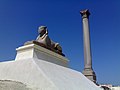
"Pompey's Pillar", a Roman triumphal column, is one of the best-known ancient monuments still standing in Alexandria today. It is located on Alexandria's ancient acropolis—a modest hill located adjacent to the city's Arab cemetery—and was originally part of a temple colonnade. Including its pedestal, it is 30 m (99 ft) high; the shaft is of polished red granite, 2.7 meters in diameter at the base, tapering to 2.4 meters at the top. The shaft is 88 feet (27 m) high made out of a single piece of granite. This would be 132 cubic meters or approximately 396 tons. Pompey's Pillar may have been erected using the same methods that were used to erect the ancient obelisks. The Romans had cranes but they were not strong enough to lift something this heavy. Roger Hopkins and Mark Lehrner conducted several obelisk erecting experiments including a successful attempt to erect a 25-ton obelisk in 1999. This followed two experiments to erect smaller obelisks and two failed attempts to erect a 25-ton obelisk.  The structure was plundered and demolished in the 4th century when a bishop decreed that Paganism must be eradicated. "Pompey's Pillar" is a misnomer, as it has nothing to do with Pompey, having been erected in 293 for Diocletian, possibly in memory of the rebellion of Domitius Domitianus. Beneath the acropolis itself are the subterranean remains of the Serapeum, where the mysteries of the god Serapis were enacted, and whose carved wall niches are believed to have provided overflow storage space for the ancient Library. In more recent years, a lot of ancient artifacts have been discovered from the surrounding sea, mostly pieces of old pottery.

Alexandria's catacombs, known as Kom al-Shoqafa, are a short distance southwest of the pillar, consist of a multi-level labyrinth, reached via a large spiral staircase, and featuring dozens of chambers adorned with sculpted pillars, statues, and other syncretic Romano-Egyptian religious symbols, burial niches, and sarcophagi, as well as a large Roman-style banquet room, where memorial meals were conducted by relatives of the deceased. The catacombs were long forgotten by the citizens until they were discovered by accident in the 1800s.

The most extensive ancient excavation currently being conducted in Alexandria is known as Kom al-Dikka. It has revealed the ancient city's well-preserved theater, and the remains of its Roman-era baths.

Persistent efforts have been made to explore the antiquities of Alexandria. Encouragement and help have been given by the local Archaeological Society, and by many individuals, notably Greeks proud of a city which is one of the glories of their national history.Excavations were performed in the city by Greeks seeking Alexander the Great tomb without success. The past and present directors of the museum have been enabled from time to time to carry out systematic excavations whenever opportunity is offered; D. G. Hogarth made tentative researches on behalf of the Egypt Exploration Fund and the Society for the Promotion of Hellenic Studies in 1895; and a German expedition worked for two years (1898–1899). But two difficulties face the would-be excavator in Alexandria: lack of space for excavation and the underwater location of some areas of interest.


Since the great and growing modern city stands immediately over the ancient one, it is almost impossible to find any considerable space in which to dig, except at enormous cost. Cleopatra VII's royal quarters were inundated by earthquakes and tidal waves, leading to gradual subsidence in the 4th century AD. This underwater section, containing many of the most interesting sections of the Hellenistic city, including the palace quarter, was explored in 1992 and is still being extensively investigated by the French underwater archaeologist Franck Goddio and his team. It raised a noted head of Caesarion. These are being opened up to tourists, to some controversy.  The spaces that are most open are the low grounds to northeast and southwest, where it is practically impossible to get below the Roman strata.

The most important results were those achieved by Dr. G. Botti, late director of the museum, in the neighborhood of “Pompey's Pillar”, where there is a good deal of open ground. Here, substructures of a large building or group of buildings have been exposed, which are perhaps part of the Serapeum. Nearby, immensecatacombs and columbaria have been opened which may have been appendages of the temple. These contain one very remarkable vault with curious painted reliefs, now artificially lit and open to visitors.

The objects found in these researches are in the museum, the most notable being a great basalt bull, probably once an object of cult in the Serapeum. Other catacombs and tombs have been opened in Kom al-Shoqqafa (Roman) and Ras al-Tiin (painted).

The German excavation team found remains of a Ptolemaic colonnade and streets in the north-east of the city, but little else. Hogarth explored part of an immense brick structure under the mound of Kom al-Dikka, which may have been part of the Paneum, the Mausolea, or a Roman fortress.

The making of the new foreshore led to the dredging up of remains of the Patriarchal Church; and the foundations of modern buildings are seldom laid without some objects of antiquity being discovered. The wealth underground is doubtlessly immense; but despite all efforts, there is not much for antiquarians to see in Alexandria outside the museum and the neighborhood of “Pompey's Pillar”.


The temple was built in the Ptolemy era and finished the construction of Alexandria. The temple is located in Abusir, the western suburb of Alexandria in Burj Al Arab city. The temple was dedicated to Osiris. Only the outer wall and the pylons remain from the temple. There is evidence to prove that sacred animals were worshipped there. Archeologists found an animal necropolis near the temple. Remains of a Christian church show that the temple was used as a church in later centuries. Also found in the same area are remains of public baths built by the emperor Justinian, a seawall, quays and a bridge. Near the beach side of the area, we can see the remains of a tower built by Ptolemy II Philadelphus. The tower was an exact scale replica of the destroyed Alexandrine Pharos Lighthouse.

Modern Alexandria is divided into six districts:
al-Montaza District: population 1,190,287
Shark (Eastern Alexandria) District: population 985,786
Wassat (Central Alexandria) District: population 520,450
al-Amriya District: population 845,845
Agamy (Western Alexandria) District: population 386,374
al-Gomrok District: population 145,558

There are also two cities under the jurisdiction of the Alexandria governorate forming metropolitan Alexandria:
Borg Al-Arab city: population 186,900
New Borg Al-Arab city: population 7,600


Maamoura, Montaza, Mandara (Bahary - Qibly), Asafra (Bahary - Qibly), Miami, Sidi Bishr (Bahary - Qibly), Saray, Victoria, Seyouf, Laurent, Tharwat, San Stefano, Gianaclis, Schutz, Zezenia, Glim, Bacchus, Saba Pasha, Fleming, Dahria, Bolkly, Stanley, Rushdy, Mustafa Kamel, Kafr Abdu, Smouha, Nozha, Sidi Gaber, Cleopatra, Sporting, Ibrahimiyya, Camp Cezar, Al Shatby, Hadara (Bahary - Qibly - New), Azarita (Originally Lazarette), Muharram Bek, El Raml Downtown, Koum Al Dikka, Eastern Harbor, Anfoushi, Manshiyya, Attarin, Karmous, (aka Karmouz), Ras El Tin, Labban, Mina El Basal, Western Harbor, Qabbary, Wardian, El Max, Dekheila, Agami Al Bitaash (Originally "Beau Tache"), Agami Al Hanuviel (Originally "Hameaux Ville"), Amreya, King Mariout, Burg al-Arab

(Ahmed) Orabi Square (Mansheya Square), in Downtown
Saad Zaghlul Square, in Downtown
Tahrir Square (formerly Mohammed Ali Square, originally Place des Consuls), in Downtown
Ahmed Zewail Square, near Wabour al-Mayah
[edit]Palaces
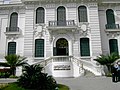
Montaza Palace, in Montaza
Ras al-Tiin Palace, in Ras al-Tiin
Presidential Palace, in Maamoura
Palais d’Antoniadis, in Smoha


Montaza Palace


Montaza palace


Tiin Palace


Antoniadis Palace

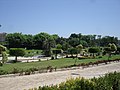
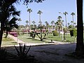
Montaza Royal Gardens
Antoniades Park
Shallalat Gardens
Alexandria Zoo
Green Plaza
Fantazy Land
Maamoura Beach, Alexandria
Marina Resort


Marina


Shallalat Gardens


Ferdinand Magellan


Nelson


Vasco da Gama


Christopher Columbus


English Garden


French Garden


Alexandria Museum


Misr Train Station


San Stefano Grand Plaza


Pompey's Pillar


Stanley Bridge


Montaza Palace


Helnan Palestine hotel


Alexandria Opera House


Places of worship in Alexandria

El-Mursi Abul Abbas Mosque

Latin Catholic church ofSaint Catherine in Mansheya

Eliyahu Hanavi Synagogue

The most famous mosque in Alexandria is El-Mursi Abul Abbas Mosque in Bahary. Other notable mosques in the city include Ali ibn Abi Talib mosque in Somouha,Bilal mosque, al-Gamaa al-Bahari in Mandara, Hatem mosque in Somouha, Hoda el-Islam mosque in Sidi Bishr, al-Mowasah mosque in Hadara, Sharq al-Madina mosque in Miami, al-Shohadaa mosque in Mostafa Kamel, Al Qa'ed Ibrahim Mosque, Yehia mosque in Zizinia, Sidi Gaber mosque in Sidi Gaber, and Sultan mosque.


After Rome, Alexandria was considered the major seat of Christianity in the world. The Pope of Alexandria was the second among equals, second only to the bishop ofRome, the capital of the Roman Empire until 430. The Church of Alexandria had jurisdiction over the entire continent of Africa. After the Council of Chalcedon in AD 451, the Church of Alexandria was split between the Miaphysites and the Melkites. The Miaphysites went on to constitute what is known today as the Coptic Orthodox Church of Alexandria. The Melkites went on the constitute what is known today as the Greek Orthodox Church of Alexandria. In the 19th century, Catholic andProtestant missionaries converted some of the adherents of the Orthodox churches to their respective faiths.

Today, the patriarchal seat of the Pope of the Coptic Orthodox Church is Saint Mark Cathedral in Ramleh. The most important Coptic Orthodox churches in Alexandria include Pope Cyril I Church in Cleopatra, Saint Georges Church in Sporting, Saint Mark & Pope Peter I Church in Sidi Bishr, Saint Mary Church in Assafra, Saint Mary Church in Gianaclis, Saint Mina Church in Fleming, Saint Mina Church in Mandara, and Saint Takla Haymanot's Church in Ibrahimeya.

The most important Greek Orthodox churches in Alexandria are Saint Anargyri Church, Church of the Annunciation, Saint Anthony Church, Archangels Gabriel&Michael Church,Taxiarchon, Saint Catherine Church, Cathedral of the Dormition in Mansheya, Church of the Dormition, Prophet Elijah Church, Saint Georges Church, Church of the Immaculate Conception in Ibrahemeya, Saint Joseph Church in Fleming, Saint Joseph of Arimathea Church, Saint Mark & Saint Nectarios Chapel in Ramleh, Saint Nicholas Church, Saint Paraskevi Church, Saint Sava Cathedral in Ramleh, and Saint Theodore Chapel. In communion with the Greek Orthodox Church is the Russian Orthodox church of Saint Alexander Nevsky in Alexandria, which serves the Russian speaking community in the city.

Churches that follow the Latin Catholic rite include Saint Catherine Church in Mansheya and Church of the Jesuits in Cleopatra.

The Saint Mark Church in Shatby, found as part of Collège Saint Marc is multi-denominational and hold liturgies according to Latin Catholic, Coptic Catholic and Coptic Orthodox rites. Copts in Alexandria have become more endangered in 2011.
[edit]Judaism
See also: History_of_the_Jews_in_Egypt

Alexandria's once-flourishing Jewish community declined rapidly following the 1948 Arab-Israeli War, after which negative reactions towards Zionism among Egyptians led to Jewish residents in the city, and elsewhere in Egypt, being perceived as Zionist collaborators. Most Jewish residents of Egypt fled to the newly established State of Israel, France, Brazil, and other countries in the 1950s and 1960s. The community once numbered 50,000 but is now estimated at below 50.      The most importantsynagogue in Alexandria is the

Alexandria has a number of higher education institutions. Alexandria University is a public university that follows the Egyptian system of higher education. Many of its faculties are internationally renowned, most notably its Faculty of Medicine & Faculty of Engineering. In addition, the Arab Academy for Science and Technology and Maritime Transport is a semi-private educational institution that offers courses for high school, undergraduate level, and postgraduate students. It is considered the most reputable university in Egypt after the AUCAmerican University in Cairo because of its worldwide recognition from (board of engineers at UK & ABET in US). Université Senghor is a private French university that focuses on the teaching of humanities, politics and international relations, which mainly targets students from the African continent. Other institutions of higher education in Alexandria include Alexandria Institute of Technology (AIT) and Pharos University in Alexandria.


Alexandria has a long history of foreign educational institutions. The first foreign schools date to the early 19th century, when French missionaries began establishing French charitable schools to educate the Egyptians. Today, the most important French schools in Alexandria run by Catholic missionaries include Collège de la Mère de Dieu, Collège Notre Dame de Sion, Collège Saint Marc, Ecoles des Soeurs Franciscaines (four different schools), École Gérard, École Saint Gabriel, École Saint-Vincent de Paul, École saint joseph, École Sainte Catherine, and Institution Sainte Jeanne-Antide. As a reaction to the establishment of French religious institutions, a secular (laic) mission established Lycée el-Horreya, which initially followed a French system of education, but is currently a public school run by the Egyptian government. The only school in Alexandria that completely follows the French educational system is École Champollion. It is usually frequented by the children of French expatriates and diplomats in Alexandria.

English schools in Alexandria are becoming the most popular schools. The most important English language schools in the city include: Riada Language School (RLS) Also known as "Leadership Schools of Languages",Alexandria Language School(ALS), Future Language School(FLS), Future International Schools :(Future IGCSE, Future American School and future new German school), Alexandria American School, British School of Alexandria, Egyptian American School, Modern American School, Sidi Gaber Language Schools, Riada American school, Taymour English School (TES), Sacred Heart Girls' School (SHS), Schutz American School, Victoria College, El Manar Language School for Girls, previously called (Scottish School for Girls), Kaumeya Language School (KLS), El Nasr Boys' School (EBS), and El Nasr Girls' College (EGC). Most of these schools were nationalized during the era ofNasser, and are currently Egyptian public schools run by the Egyptian ministry of education.

There are only two German schools in Alexandria which are Deutsche Schule der Borromärinnen (DSB of Saint Charles Borromé) and Future Deutsche Schule.

The Montessori educational system was first introduced in Alexandria in 2009 at Alexandria Montessori.

N.B: The most notable public schools in Alexandria include, AlAbasseia High School, Gamal Abdel Nasser High School and EL Manar language School for girls.

Royal Road

The Persian Royal Road was an ancient highway reorganized and rebuilt by the Persian king Darius the Great (Darius I) of theAchaemenid Empire in the 5th century BC.    Darius built the road to facilitate rapid communication throughout his very large empire from Susa to Sardis ("centralized rule is the victim of time and distance," Robin Lane Fox has observed in this context).  Mounted couriers could travel 1,677 miles (2,699 km) in seven days; the journey from Susa to Sardis took ninety days on foot. The Greek historian Herodotus wrote, "There is nothing in the world that travels faster than these Persian couriers." Herodotus's praise for these messengers—"Neither snow, nor rain, nor heat, nor darkness of night prevents these couriers from completing their designated stages with utmost speed"— was inscribed on the James Farley Post Office in New York and is sometimes thought of as the United States Postal Service creed.

The course of the road has been reconstructed from the writings of Herodotus,  archeological research, and other historical records. It began in Asia Minor (on the Aegean coast of Lydia, about 60 miles east of İzmir in present-day Turkey), traveled east through what is now the middle northern section of Turkey, (crossing the Halys according to Herodotus) and passed through the Cilician Gates to the old Assyrian capital Nineveh (present-day MosulIraq), then turned south to Babylon (near present-day BaghdadIraq). From near Babylon, it is believed to have split into two routes, one traveling northeast then east throughEcbatana and on along the Silk Road, the other continuing east through the future Persian capital Susa (in present-day Iran) and then southeast to Persepolis. Of course, such long routes for travellers and tradesmen would often take months on end, and so during the reign of Darius the Great numerous royal outposts (Caravanserai) were built.
Because the road did not follow the shortest nor the easiest route between the important cities of the Persian Empire, archeologists believe the westernmost sections of the road may have originally been built by the Assyrian kings, as the road plunges through the heart of their old empire. More eastern segments of the road, identifiable in present-day northern Iran, were not noted by Herodotus, whose view of Persia was that of an Ionian Greek in the West; stretches of the Royal Road across the central plateau of Iran are coincident with the major trade route known as the Silk Road.
However, Darius I made the Royal Road as it is recognized today. A later improvement by the Romans of a road bed with a hard-packed gravelled surface of 6.25 m width held within a stone curbing was found in a stretch near Gordium  and connecting the parts together in a unified whole stretching some 1500 miles, primarily as a post road, with a hundred and eleven posting stations maintained with a supply of fresh horses, a quick mode of communication using relays of swift mounted messengers, the kingdom's pirradazis.
The construction of the road as improved by Darius was of such quality that the road continued to be used until Roman times. A bridge at DiyarbakırTurkey, still stands from this period of the road's use. The road also helped Persia increase long-distance trade, which reached its peak during the time of Alexander the Great (Alexander III of Macedon).
In 1961, under a grant from the American Philosophical Society, S. F. Starr traced the stretch of road from Gordium to Sardis, identifying river crossings by ancient bridge abutments. 
Euclid is said to have replied to King Ptolemy's request for an easier way of learning mathematics that "there is no Royal Road to geometry," following Proclus. 
Charles Sanders Peirce, in his How to Make Our Ideas Clear (1878), says, "There is no royal road to logic, and really valuable ideas can only be had at the price of close attention." This essay was claimed by William James as instrumental in the foundation of the philosophical school of pragmatism. Sigmund Freud also famously described dreams as the "royal road to the unconscious"  
The Royal Road to Romance (1925) is the first book by Richard Halliburton, covering his world travels as a young man from Andorra to Angkor.

Silk Road

  The Silk Road (from German: Seidenstraße) or Silk Route is a modern term referring to a historical network of interlinking trade routes across the Afro-Eurasian landmass that connected East, South, and Western Asia with the Mediterranean and European world, as well as parts of North and East Africa. Extending 4,000 miles (6,500 km), the Silk Road gets its name from the lucrative Chinese silk trade along it, which began during the Han Dynasty (206 BC – 220 AD). The central Asian sections of the trade routes were expanded around 114 BC by the Han dynasty, largely through the missions and explorations of Zhang Qian,  but earlier trade routes across the continents already existed.
Trade on the Silk Road was a significant factor in the development of the civilizations of ChinaIndiaPersiaEurope and Arabia. Though silk was certainly the major trade item from China, many other goods were traded, and various technologies, religions and philosophies, as well as the bubonic plague (the "Black Death"), also traveled along the Silk Routes.
The main traders during Antiquity were the Indian and Bactrian traders, then from the 5th to the 8th century the Sogdian traders, then afterward the Arab and Persian traders.

The Silk Road gets its name from the lucrative Chinese silk trade, a major reason for the connection of trade routes into an extensive transcontinental network. 
The German terms "Seidenstraße" and "Seidenstraßen"- 'the Silk Road(s)' or 'Silk Route(s)' were coined by Ferdinand von Richthofen, who made seven expeditions to China from 1868 to 1872.  Some scholars prefer the term "Silk Routes" because the road included an extensive network of routes, though few were more than rough caravan tracks.
As the domestication of pack animals and the development of shipping technology both increased the capacity for prehistoric peoples to carry heavier loads over greater distances, cultural exchanges and trade developed rapidly. In addition, grassland provides fertile grazing, water, and easy passage for caravans. The vast grassland steppes of Asia enabled merchants to travel immense distances, from the shores of the Pacific to Africa and deep into Europe, without trespassing on agricultural lands and arousing hostility.
From the 2nd millennium BC nephrite jade was being traded from mines in the region of Yarkand and Khotan to China. Significantly, these mines were not very far from the lapis lazuli and spinel ("Balas Ruby") mines in Badakhshan and, although separated by the formidable Pamir Mountains, routes across them were, apparently, in use from very early times.

The Tarim mummies have been found in the Tarim Basin, in the area of Loulan located along the Silk Road 200 km East of Yingpan, dating to as early as 1600 BC and suggesting very ancient contacts between East and West. These mummified remains may have been of people who spoke Indo-European languages, that remained in use in the Tarim Basin, in the modern day Xinjiang region, until replaced by Turkic influences from the northernXiongnu Empire, and by Chinese influences from the eastern Han Dynasty, who spoke a Sino-Tibetan language.
Following contacts of metropolitan China with nomadic western border territories in the 8th century BC, gold was introduced from Central Asia, and Hotan Kashteshi Hotan jade carvers began to make imitation designs of thesteppes, adopting the Scythian-style animal art of the steppes (depictions of animals locked in combat). This style is particularly reflected in the rectangular belt plaques made of gold and bronze with alternate versions in jade and steatite.
The expansion of Scythian cultures stretching from the Hungarian plain and the Carpathians to the ChineseKansu Corridor and linking Iran, and the Middle East with Northern India and the Punjab, undoubtedly played an important role in the development of the Silk Road. Scythians accompanied the Assyrian Esarhaddon on his invasion of Egypt, and their distinctive triangular arrowheads have been found as far south as Aswan. These nomadic peoples were dependent upon neighbouring settled populations for a number of important technologies, and in addition to raiding vulnerable settlements for these commodities, also encouraged long distance merchants as a source of income through the enforced payment of tariffs. Soghdian Scythian merchants played a vital role in later periods in the development of the Silk Road.
 By the time of Herodotus (c. 475 BC), the Royal Road of the Persian Empire ran some 2,857 km from the city of Susa on the Karun (250 km east of the Tigris) to the port of Smyrna (modern İzmir in Turkey) on the Aegean Sea.  It was maintained and protected by the Achaemenid Empire (c. 500–330 BC), and had postal stations and relays at regular intervals. By having fresh horses and riders ready at each relay, royal couriers could carry messages the entire distance in nine days, while normal travellers took about three months. This Royal Road linked into many other routes. Some of these, such as the routes to India and Central Asia, were also protected by the Achaemenids, encouraging regular contact between India, Mesopotamia and the Mediterranean. There are accounts in the biblical Book of Esther of dispatches being sent from Susa to provinces as far out as India and the Kingdom of Kush during the reign of Xerxes the Great (485–465 BC).

The first major step in opening the Silk Road between the East and the West came with the expansion of Alexander the Great's empire intoCentral Asia. In August 329 BC, at the mouth of the Fergana Valley in Tajikistan he founded the city of Alexandria Eschate or "Alexandria The Furthest". This later became a major staging point on the northern Silk Route.
The Greeks remained in Central Asia for the next three centuries, first through the administration of the Seleucid Empire, and then with the establishment of the Greco-Bactrian Kingdom in Bactria. They continued to expand eastward, especially during the reign of Euthydemus (230–200 BC) who extended his control beyond Alexandria Eschate to Sogdiana. There are indications that he may have led expeditions as far as Kashgar in Chinese Turkestan, leading to the first known contacts between China and the West around 200 BC. The Greek historian Strabo writes "they extended their empire even as far as theSeres (China) and the Phryni."  
With the Mediterranean linked to the Fergana Valley, the next step was to open a route across the Tarim Basin and the Gansu Corridor to China Proper. This came around 130 BC, with the embassies of the Han Dynasty to Central Asia, following the reports of the ambassador Zhang Qian  (who was originally sent to obtain an alliance with the Yuezhi against the Xiongnu). After the defeat of the Xiongnu, however, Chinese armies established themselves in Central Asia, starting the famed Silk Road, which became a major avenue of international trade.  Some say that the Chinese Emperor Wu became interested in developing commercial relationships with the sophisticated urban civilizations of FerghanaBactria and Parthian Empire: "The Son of Heaven on hearing all this reasoned thus: Ferghana (Dayuan) and the possessions of Bactria (Ta-Hsia) and Parthian Empire (Anxi) are large countries, full of rare things, with a population living in fixed abodes and given to occupations somewhat identical with those of the Chinese people, but with weak armies, and placing great value on the rich produce of China" (Hou HanshuLater Han History). Others  say that Emperor Wu was mainly interested in fighting the Xiongnu and that major trade began only after the Chinese pacified the Hexi Corridor.
The Chinese were also strongly attracted by the tall and powerful horses (named "Heavenly horses") in the possession of the Dayuan, which were of capital importance in fighting the nomadic Xiongnu. The Chinese subsequently sent numerous embassies, around ten every year, to these countries and as far as SeleucidSyria. "Thus more embassies were dispatched to Anxi [Parthia], Yancai [who later joined the Alans ], Lijian [Syria under the Seleucids], Tiaozhi [Chaldea], and Tianzhu [northwestern India]… As a rule, rather more than ten such missions went forward in the course of a year, and at the least five or six." (Hou Hanshu, Later Han History). The Roman historian Florus also describes the visit of numerous envoys, including Seres, to the first Roman Emperor Augustus, who reigned between 27 BC and 14 AD:

Even the rest of the nations of the world which were not subject to the imperial sway were sensible of its grandeur, and looked with reverence to the Roman people, the great conqueror of nations. Thus even Scythians and Sarmatians sent envoys to seek the friendship of Rome. Nay, the Seres came likewise, and the Indians who dwelt beneath the vertical sun, bringing presents of precious stones and pearls and elephants, but thinking all of less moment than the vastness of the journey which they had undertaken, and which they said had occupied four years. In truth it needed but to look at their complexion to see that they were people of another world than ours.
— Henry YuleCathay and the way thither


The "Silk Road" originated during the 1st century BC, following efforts by the Yuezhi and Xiongnu in the Tarim Basin to consolidate a road to the Western world and India, both through direct settlements in the area of the Tarim Basin and diplomatic relations with the countries of the Dayuan, Parthians and Bactrians further west. The Silk Roads were a "complex network of trade routes" that gave people the chance to exchange goods and culture. 
Soon after the Roman conquest of Egypt in 30 BC, regular communications and trade between China, Southeast Asia, India, the Middle East, Africa and Europe blossomed on an unprecedented scale. The Greco-Roman trade with India started by Eudoxus of Cyzicus in 130 BC kept on increasing, and according to Strabo (II.5.12), by the time of Augustus, up to 120 ships were setting sail every year from Myos Hormos in Roman Egypt to India. 
The party of Maës Titianus became the travellers who penetrated farthest east along the Silk Road from the Mediterranean world, probably with the aim of regularizing contacts and reducing the role of middlemen, during one of the lulls in Rome's intermittent wars with Parthia, which repeatedly obstructed movement along the Silk Road. Intercontinental trade and communication became regular, organized, and protected by the 'Great Powers.' Intense trade with the Roman Empire soon followed, confirmed by the Roman craze for Chinese silk (supplied through the Parthians), even though the Romans thought silk was obtained from trees. This belief was affirmed by Seneca the Younger in his Phaedra and by Virgil in his Georgics. Notably, Pliny the Elder knew better. Speaking of the bombyx or silk moth, he wrote in his Natural Histories "They weave webs, like spiders, that become a luxurious clothing material for women, called silk." 
The Roman Senate issued, in vain, several edicts to prohibit the wearing of silk, on economic and moral grounds: the importation of Chinese silk caused a huge outflow of gold, and silk clothes were considered to be decadent and immoral:
I can see clothes of silk, if materials that do not hide the body, nor even one's decency, can be called clothes… Wretched flocks of maids labour so that the adulteress may be visible through her thin dress, so that her husband has no more acquaintance than any outsider or foreigner with his wife's body. 
The unification of Central Asia and Northern India within Kushan Empire in the 1st to 3rd centuries reinforced the role of the powerful merchants from Bactria and Taxila. They fostered multi-cultural interaction as indicated by their 2nd century treasure hoards filled with products from the Greco-Roman world, China and India, such as in the archeological site of Begram.
The Roman Empire, and its demand for sophisticated Asian products, crumbled in the West around the 5th century.
Byzantine historian Procopius stated that two Christian monks eventually uncovered the way of how silk was made. From this revelation spies were sent to steal the silkworm eggs, resulting in silk production in the Mediterranean. 


The Silk Road represents an early phenomenon of political and cultural integration due to inter-regional trade. In its heyday, it sustained an international culture that strung together groups as diverse as the MagyarsArmenians, and Chinese. The route experienced its prime periods of popularity and activity in differing eras at different points along its length.
In the west, the Silk Road reached its peak during the time of the Byzantine Empire; in the Nile-Oxus section, from the Sassanid Empire period to the Il Khanate period; and in the sinitic zone from the Three Kingdoms period to the Yuan Dynasty period. Trade between East and West also developed on the sea, between Alexandria in Egypt and Guangzhou in China, fostering across the Indian Ocean.
Under its strong integrating dynamics on the one hand and the impacts of change it transmitted on the other, tribal societies previously living in isolation along the Silk Road or pastoralists who were of barbarian cultural development were drawn to the riches and opportunities of the civilizations connected by the Silk Road, taking on the trades of marauders or mercenaries. Many barbarian tribes became skilled warriors able to conquer rich cities and fertile lands, and forge strong military empires.
A.V. Dybo noted that "according to historians, the main driving force of the Great Silk Road were not just Sogdians, but the carriers of a mixed Sogdian-Türkic culture that often came from mixed families."  
The Sogdians dominated the East-West trade after the 4th century up to the 8th century, with Suyab and Talas ranking among their main centers in the north. They were the main caravan merchants of Central Asia. Their commercial interests were protected by the resurgent military power of the Göktürks, whose empire has been described as "the joint enterprise of the Ashina clan and the Soghdians".  Their trades with some interruptions continued in the 9th century within the framework of the Uighur Empire, which until 840 extended across northern Central Asia and obtained from China enormous deliveries of silk in exchange for horses. At this time caravans of Sogdians traveling to Upper Mongolia are mentioned in Chinese sources. They played an equally important religious and cultural role. Part of the data about eastern Asia provided by Muslim geographers of the 10th century actually goes back to Sogdian data of the period 750–840 and thus shows the survival of links between east and west. However, after the end of the Uighur Empire, Sogdian trade went through a crisis. What mainly issued from Muslim Central Asia was the trade of the Samanids, which resumed the northwestern road leading to the Khazars and the Urals and the northeastern one toward the nearby Turkic tribes. 


The Silk Road gave rise to the clusters of military states of nomadic origins in North China, invited the NestorianManichaeanBuddhist, and laterIslamic religions into Central Asia and China, created the influential Khazar Federation and at the end of its glory, brought about the largest continental empire ever: the Mongol Empire, with its political centers strung along the Silk Road (Beijing in North China, Karakorum in central Mongolia,Sarmakhand in TransoxianaTabriz in Northern Iran, Sarai and Astrakhan in lower VolgaSolkhat in CrimeaKazan in Central Russia, Erzurum in eastern Anatolia), realizing the political unification of zones previously loosely and intermittently connected by material and cultural goods.
In Central Asia, Islam expanded from the 7th century onward, bringing a stop to Chinese westward expansion at the Battle of Talas in 751. Further expansion of the Islamic Turks in Central Asia from the 10th century finished disrupting trade in that part of the world, and Buddhism almost disappeared. For much of the Middle Ages, the Islamic Caliphate (centred in the Near East) often had a monopoly over much of the trade conducted across the Old World (see Muslim age of discovery for more details).
The Mongol expansion throughout the Asian continent from around 1207 to 1360 helped bring political stability and re-establish the Silk Road (viaKarakorum). It also brought an end to the Islamic Caliphate's monopoly over world trade. Because the Mongols had dominated the trade routes, it allowed more trade to come in and out of the region. Merchandise that did not seem valuable to the Mongols was often seen as very valuable by the west. As a result, the Mongols received in return a large amount of luxurious goods from the West. However, they never abandoned their nomadic lifestyle. Soon after Genghis Khan died, the Silk Road was in the hand of Genghis Khans' daughters. The Mongol diplomat Rabban Bar Sauma visited the courts of Europe in 1287–1288 and provided a detailed written report back to the Mongols. Around the same time, the Venetian explorer Marco Polobecame one of the first Europeans to travel the Silk Road to China, and his tales, documented in The Travels of Marco Polo, opened Western eyes to some of the customs of the Far East. He was not the first to bring back stories, but he was one of the widest-read. He had been preceded by numerous Christian missionaries to the East, such as William of RubruckBenedykt PolakGiovanni da Pian del Carpine, and Andrew of Longjumeau. Later envoys included Odoric of PordenoneGiovanni de' MarignolliJohn of MontecorvinoNiccolò de' Conti, or Ibn Battuta, a Moroccan Muslimtraveller, who passed through the present-day Middle East and across the Silk Road from Tabriz, between 1325–1354. 
The 13th century also saw attempts at a Franco-Mongol alliance, with exchange of ambassadors and (failed) attempts at military collaboration in theHoly Land during the later Crusades, though eventually the Mongols in the Ilkhanate, after they had destroyed the Abbasid and Ayyubid dynasties, eventually themselves converted to Islam, and signed the 1323 Treaty of Aleppo with the surviving Muslim power, the Egyptian Mamluks.
Some research studies indicate that the Black Death, which devastated Europe in the late 1340s, may have reached from Central Asia (or China) to Europe along the trade routes of the Mongol Empire. 
The fragmentation of the Mongol Empire loosened the political, cultural and economic unity of the Silk Road. Turkmeni marching lords seized land around the western part of the Silk Road, belonging to the decaying Byzantine Empire. After the Mongol Empire, the great political powers along the Silk Road became economically and culturally separated. Accompanying the crystallization of regional states was the decline of nomad power, partly due to the devastation of the Black Death and partly due to the encroachment of sedentary civilizations equipped with gunpowder.
Gunpowder and early modernity in Europe led to the integration of territorial states and increasing mercantilism. Meanwhile on the Silk Road, gunpowder and early modernity had the opposite impact: the level of integration of the Mongol Empire could not be maintained, and trade declined (though partly due to an increase in European maritime exchanges).
The Silk Road stopped serving as a shipping route for silk about 1453 with the Ottoman supremacy at Constantinople. Ottoman rulers of the day were anti-western, countering the crusades, and aware of the loss of Andalusia in the west, so expressed their displeasure by embargoing trade with the west. Things had eased a bit around a century later, and Venice was able to cut an uneasy deal with the Ottomans, regaining for a time some of their economic clout as middlemen.
The disappearance of the Silk Road following the end of the Mongols' reign was one of the main factors that stimulated the Europeans to reach the prosperous Chinese empire through another route, especially by sea. Tremendous profits were to be obtained for anyone who could achieve a direct trade connection with Asia. This was the main driving factor for the Portuguese explorations of the Indian Ocean, including the sea of China, resulting in the arrival in 1513 of the first European trading ship to the coasts of China, under Jorge Álvares and Rafael Perestrello, followed by the Fernão Pires de Andrade and Tomé Pires diplomatic and commercial mission of 1517, under the orders of Manuel I of Portugal, which opened formally relations between thePortuguese Empire and the Ming Dynasty during the reign of the Zhengde Emperor. The handover of Macau (Macao) to Portugal in 1557 by the Emperor of China  (as a reward for services rendered against the pirates who infested the South China Sea) resulted in the first permanent European maritime trade post between Europe and China, with other European powers following suit over the next centuries, which caused the eventual demise of the Silk Road.


When he went West in 1492, Christopher Columbus reportedly wished to create yet another trade route to China.  It was initially a great disappointment to have found a continent "in-between" before recognizing the potential of a "New World".
In 1594, Willem Barents left Amsterdam with two ships to search for the Northeast passage north of Siberia, on to eastern Asia. He reached the west coast of Novaya Zemlya and followed it northward, being finally forced to turn back when confronted with its northern extremity. By the end of the 17th century, the Russians re-established a land trade route between Europe and China under the name of the Great Siberian Road.
The desire to trade directly with China and India was also the main driving force behind the expansion of the Portuguese beyond Africa after 1480, followed by the Netherlands and England from the 17th century. While the Portuguese (and, subsequently, other Europeans) were entering China from its southern coast, by the sea route, the question arose as to whether it happens to be the same country as Cathay which Marco had reached by the overland route. By c. 1600, the Jesuits stationed in China, led by Matteo Ricci, were pretty sure that it was, but others were not convinced yet. To check the situation on the ground, Bento de Góis, a Portuguese former soldier and explorer who had joined the Jesuits as a Lay Brother in Goa, India, traveled in 1603–1605 from India via Afghanistan and one of the routes of the traditional Silk Road (via Badakhshan, the PamirsYarkandKucha, andTurpan to the Ming China's border as Suzhou, Gansu. 
Leibniz, echoing the prevailing perception in Europe until the Industrial Revolution, wrote in the 17th century that: Everything exquisite and admirable comes from the East Indies... Learned people have remarked that in the whole world there is no commerce comparable to that of China.
In the 18th century, Adam Smith declared that China had been one of the most prosperous nations in the world, but that it had remained stagnant for a long time and its wages always were low and the lower classes were particularly poor: 
China has long been one of the richest, that is, one of the most fertile, best cultivated, most industrious, and most populous countries in the world. It seems, however, to have been long stationary. Marco Polo, who visited it more than five hundred years ago, describes its cultivation, industry, and populousness, almost in the same terms as travellers in the present time describe them. It had perhaps, even long before his time, acquired that full complement of riches which the nature of its laws and institutions permits it to acquire. 
The Eurasian Land Bridge is sometimes referred to as the "New Silk Road". The last link in a railway route along the Silk Road was completed in 1990, when the railway systems of China and Kazakhstan connected in Alataw Pass (Alashan Kou). Currently (2008), the line is used by direct passenger service from Urumqi in China's Xinjiang to Almaty and Astana in Kazakhstan. 

Since July 2011 Chongqing is officially linked to Duisburg, Germany by a freight rail across Eurasia.
 Compared to the traditional sea trade routes from Guangzhou and Shanghai, the rail link to Europe cuts travel time to Europe from about 36 days by container ship to just 13 days by freight train.
The Silk Road comprised several routes.
As it extends westwards from the ancient commercial centers of China, the overland, intercontinental Silk Road divides into the northern and southern routes by passing the Taklimakan Desert and Lop Nur.
The northern route started at Chang'an (now called Xi'an), the capital of the ancient Chinese Kingdom, which, in the Later Han, was moved further east to Luoyang. The route was defined about the 1st century BC as Han Wudi put an end to harassment by nomadic tribes. 
The northern route travelled northwest through the Chinese province of Gansu from Shaanxi Province, and split into three further routes, two of them following the mountain ranges to the north and south of the Taklamakan Desert to rejoin at Kashgar; and the other going north of the Tian Shan mountains through TurpanTalgar and Almaty (in what is now southeast Kazakhstan). The routes split again west of Kashgar, with a southern branch heading down the Alai Valley towards Termez (in modern Uzbekistan) and Balkh (Afghanistan), while the other traveled through Kokand in the Fergana Valley (in present-day eastern Uzbekistan) and then west across the Karakum Desert. Both routes joined the main southern route before reaching Merv (Turkmenistan). A route for caravans, the northern Silk Road brought to China many goods such as "dates, saffron powder and pistachio nuts from Persia; frankincense, aloes and myrrh from Somalia; sandalwood from India; glass bottles from Egypt, and other expensive and desirable goods from other parts of the world."  In exchange, the caravans sent back bolts of silk brocade, lacquer ware and porcelain. Another branch of the northern route turned northwest past the Aral Sea and north of the Caspian Sea, then and on to the Black Sea.
The southern route or Karakoram route was mainly a single route running from China, through the Karakoram, where it persists to modern times as the international paved road connecting Pakistan and China as the Karakoram Highway. It then set off westwards, but with southward spurs enabling the journey to be completed by sea from various points. Crossing the high mountains, it passed through northern Pakistan, over the Hindu Kush mountains, and into Afghanistan, rejoining the northern route near Merv. From there, it followed a nearly straight line west through mountainous northern IranMesopotamia and the northern tip of the Syrian Desert to the Levant, where Mediterranean trading ships plied regular routes to Italy, while land routes went either north through Anatolia or south to North Africa. Another branch road traveled from Herat through Susa to Charax Spasinu at the head of the Persian Gulf and across to Petra and on toAlexandria and other eastern Mediterranean ports from where ships carried the cargoes to Rome.
The southwest route is believed to be the Ganges/Brahmaputra Delta which has been the subject of international interest for over two millennia. Strabo, the 1st Century Roman writer, mentions the deltaic lands: ‘Regarding merchants who now sail from Egypt…as far as the Ganges, they are only private citizens...’ His comments seem to be interesting since the Roman beads and other materials are being found at Wari-Bateshwar ruins, the ancient city with roots from much earlier before the Bronze Age presently being slowly excavated beside the Old Brahmaputra inBangladesh. Ptolemy’s map of the Ganges Delta, a remarkably accurate piece of mapping, showed quite clearly that his informants knew all about the course of the Brahmaputra River, crossing through the Himalayas then bending westward to its source in Tibet. It is doubtless that this delta was a major international trading center, almost certainly from much earlier than the Common Era. Gemstones and other merchandise from Thailand and Java were traded in the delta and through it. A famous Chinese archaeological writer Bin Yang, whose work, ‘Between Winds and Clouds; The Making of Yunnan’, published in 2004 by the Columbia University press and some earlier writers and archaeologists, such as Janice Stargardt strongly suggest this route of international trade as Sichuan-Yunnan-Burma-Bangladesh route. According to Bin Yang, especially from the 12th century the route was used to ship bullion from Yunnan (Gold and Silver being amongst the minerals in which Yunnan is rich), through northern Burma, into modern Bangladesh, making use of the ancient route, known as the ‘Ledo’ route. The emerging evidence of the ancient cities of Bangladesh, in particular Wari-Bateshwar ruinsMahasthangarhBhitagarhBikrampur, Egarasindhur and Sonargaon are believed to be the international trade centers in this route.
Richard FoltzXinru Liu and others have described how trading activities along the Silk Road over many centuries facilitated the transmission not just of goods but also ideas and culture, notably in the area of religions. ZoroastrianismJudaismBuddhism,ChristianityManichaeism, and Islam all spread across Eurasia through trade networks that were tied to specific religious communities and their institutions. The spread of religions and cultural traditions along the Silk Roads, according to Jerry H. Bentley, also led to syncretism. One example was the encounter with the Chinese and Xiongnu nomads. These unlikely events of cross-cultural contact allowed both cultures to adapt to each other as an alternative. The Xiongnu adopted Chinese agricultural techniques, dress style, and lifestyle. On the other hand, the Chinese adopted Xiongnu military techniques, some dress style, and music and dance.  Of all the cultural exchanges between China and the Xiongnu, the defection of Chinese soldiers was perhaps the most surprising. They would sometimes convert to the Xiongnu way of life and stay in the stepps for fear of punishment. 
Many artistic influences were transmitted via the Silk Road, particularly through Central Asia, where HellenisticIranian, Indian and Chinese influences could intermix. Greco-Buddhist artrepresents one of the most vivid examples of this interaction.
These artistic influences can also be seen in the development of Buddhism, where, for instance, Buddha was first depicted as human in the Kushan period. Many scholars have attributed this to Greek influence. The mixture of Greek and Indian elements can be found in later Buddhist art in China and throughout countries on the Silk Road.
The transmission of Buddhism to China via the Silk Road began in the 1st century AD, according to a semi-legendary account of an ambassador sent to the West by the Chinese Emperor Ming (58–75 AD). During this period Buddhism began to spread throughout Southeast, East, and Central Asia.  The Buddhist movement was the first large-scale missionary movement in the history of world religions. Buddha’s community of followers, the Sangha, consisted of male and female monks and laity. These people moved through India and beyond to spread the ideas of Buddha. Extensive contacts started in the 2nd century AD, probably as a consequence of the expansion of the Kushan empire into the Chinese territory of the Tarim Basin, due to the missionary efforts of a great number of Central Asian Buddhist monks to Chinese lands. The first missionaries and translators of Buddhists scriptures into Chinese were either Parthian, Kushan, Sogdian or Kuchean. 
One result of the spread of Buddhism along the Silk Road was displacement and conflict. The Greek Seleucids were exiled to Iran and Central Asia due to a new Iranian Dynasty called the Parthians at the beginning of the 2nd century BCE, and as a result the Parthians became the new middle men for trade in a period when the Romans were major customers for silk. The Parthians were Buddhists and, because they found themselves in a main trade centre on the Silk Road, the city of Marv became a major Buddhist centre by the middle of the 2nd century.  Knowledge among people on the silk roads also increased when Emperor Ashoka of the Maurya dynasty (268-239 BCE) converted to Buddhism and raised the religion to official status in his northern Indian empire. 
From the 4th century onward, Chinese pilgrims also started to travel on the Silk Road to India, in order to get improved access to the original Buddhist scriptures, with Fa-hsien's pilgrimage to India (395–414), and later Xuan Zang (629–644) and Hyecho, who traveled from Korea to India. The legendary accounts of the holy priest Xuan Zang were described in a novel called Journey to the West, which told of trials with demons, but also the help of various disciples on the journey.
There were many different schools of Buddhism travelling on the Silk Road. The Dharmaguptakas and the Sarvastivadins were two of the major nikaya schools. These were both eventually displaced by the Mahayana, also known as “Great Vehicle”. This movement of Buddhism first gained influence in the Khotan region.  The Mahayana, which was more of a “pan-Buddhist movement” than a school of Buddhism, appears to have begun in north western India or Central Asia. It was small at first and formed during the 1st century BCE, and the origins of this “Greater Vehicle” are not fully clear. Some Mahayana scripts were found in northern Pakistan but the main texts are still believed to have been composed in Central Asia along the Silk Road. These different schools and movements of Buddhism were a result of the diverse and complex influences and beliefs on the Silk Road. 
During the 5th and 6th centuries BCE, Merchants played a large role in the spread of religion, in particular Buddhism. Merchants found the moral and ethical teachings of Buddhism to be an appealing alternative to previous religions. As a result, Merchants supported Buddhist Monasteries along the Silk Roads and in return the Buddhists gave the Merchants somewhere to stay as they traveled from city to city. As a result, Merchants spread Buddhism to foreign encounters as they traveled. Merchants also helped to establish diaspora within the communities they encountered and overtime their cultures became based on Buddhism. Because of this, these communities became centers of literacy and culture with well-organized marketplaces, lodging, and storage. The Silk Road transmission of Buddhism essentially ended around the 7th century with the rise of Islam in Central Asia.
Both Bishkek and Almaty now have a major east-west street named after the Silk Road  
Artifacts from the history of the Silk Route are displayed at the Silk Route Museum in Jiuquan, China.